🗂️Guides🏙️Cities📮Pins🌍Countries🚇Getting Around📍My lists😻Cats📖About
Everything else
🏠Home🔐Privacy & data📜Terms of use🧾Sources & credits⛷️Cat-Ski↗ (opens in a new tab)👤Whisker Leaks↗ (opens in a new tab)
🗂️Guides🏙️Cities📮Pins🌍Countries🚇Getting Around📍My lists😻Cats📖About
Everything else
🏠Home🔐Privacy & data📜Terms of use🧾Sources & credits⛷️Cat-Ski↗ (opens in a new tab)👤Whisker Leaks↗ (opens in a new tab)
PostcardsMapTableStats

Plan Zermatt

Current conditions and the practical reference material that helps turn the saved places into a trip.

The next week in Zermatt

7-day forecast from Open-Meteo. UV badges flag days when sun protection matters (3 and above is moderate; 8 and above is risk territory for unprotected fair skin within 30 minutes).

Today
Overcast
24° / 15°
UV High
Wed
Showers
24° / 14°
UV High
Thu
Showers
20° / 13°
0.7 mm
UV High
Fri
Fog
20° / 10°
UV High
Sat
Partly cloudy
20° / 13°
UV High
Sun
Overcast
18° / 15°
2.1 mm
UV High
Mon
Fog
19° / 14°
UV High

Climate

Summer (Jun-Sep)

Typical highs around 13°C, lows around 4°C.

Winter (Dec-Mar)

Typical highs around -4°C, lows around -13°C.

In August 4

Drag to scrub across the year.

JFMAMJJASOND
Weather
14° / 5°
Typical high / low
3 mm rainfall this month
Daylight
14.2h
06:27 – 20:40local
Holidays coming up

Public holidays from Nager.Date.

Airports

closest MXP · 87 km

Getting around Zermatt

Public-transit operators within 8 km of the city center. Click through to each operator’s site for routes, fares, and tickets.

Local transit operators
VectareRVSSchweizerische Bundesbahnen SBBGornergratbahnZermatt Bergbahnen AGMatterhorn Gotthard Bahn (fo)Elektrobus ZermattPostAuto AGLEXMatterhorn Gotthard Bahn (bvz)FlixBus-eu

About Zermatt

Zermatt is a municipality in the district of Visp in the German-speaking section of the canton of Valais in Switzerland. It has a year-round population of about 5,800 and is classified as a town by the Swiss Federal Statistical Office (FSO).

Area
243 km²
Switzerland basics →Country context, advisories, and entry links for the practicalities shown above.
References5▾▴

The links below support the changing or licensed reference material on this page. Personal notes and ordinary geographic facts are not footnoted individually.

  1. City background. Wikipedia summary may be clipped or paraphrased. Structured fields are cross-checked against the related references. Related: Wikidata, Open-Elevation, IANA Time Zone Database, CC BY-SA 4.0.
JFMAMJJASOND17°-17°
highlowrainfallcomfortable months

Monthly highs, lows, rainfall — long-term averages, NASA POWER.

DB Regio AG NRW
Hessische Landesbahn
BlaBlaCar Bus↗ (opens in a new tab)
FlixBus-de
FlixBus-de
FlixBus-de
Interimsfahrplan / Horaire interimaire / Orario ad interim
Trenitalia France
SBB Infrastruktur AG Bahnersatz

Operators and modes are aggregated from individual transit-agency GTFS feeds. Route classifications come from each feed’s route type codes.

  • Weather and climate. Seven-day forecast and long-term monthly climate for the city coordinates. Related: NASA POWER, Open-Meteo license.
  • Getting around. Transit operators from agency GTFS feeds and nearby commercial-airport reference data. Related: OurAirports.
  • Public holidays. Upcoming public-holiday dates used in the annual planning scrubber.
  • City flag source. Public domain, Original: M. Hans Lengweiler Vector: ARK.
  • Maps, image licenses, and the full dataset registry are listed in site credits.

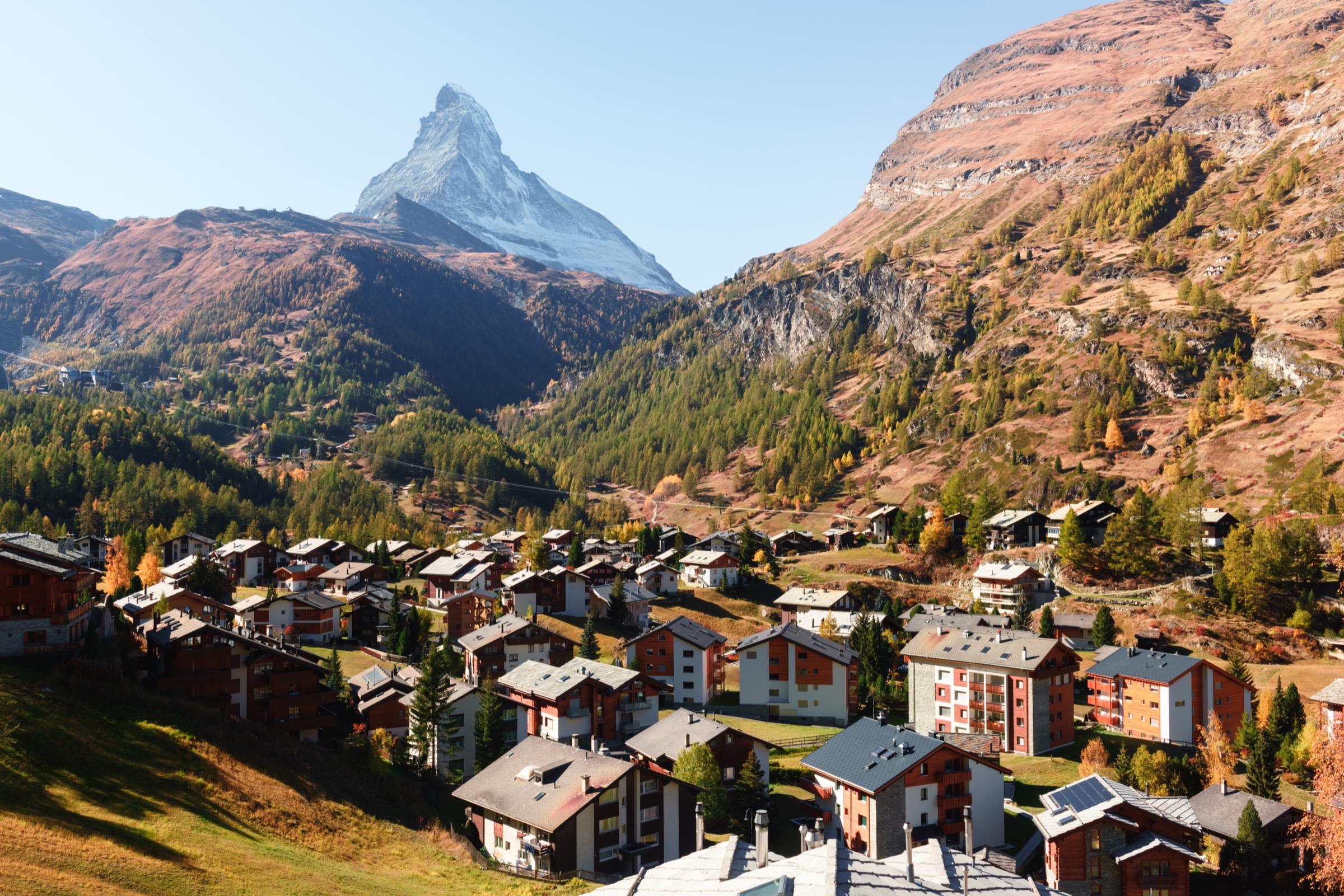
    Zermatt village street with the Matterhorn beyond.
    Cities›Switzerland›Zermatt

    Zermatt, the car-free village under the Matterhorn

    A compact Zermatt food note: village and mountain restaurants to plan around on a Matterhorn trip.

    Updated
    Jul 6, 2026
    📍View my pins on Google↗◎Things to do in Zermatt→
    BeenDfc📍3 places

    Zermatt at a glance

    Local time   · Europe/Zurich
    Today
    Overcast24° / 15°
    Travel basics
    Tap water
    Safe to drink
    Electricity
    230V/50Hz · Type C / J
    Drives on
    Right
    Currency
    CHF CHF
    Language
    German, French, Italian, Romansh
    US passport
    Visa-free

    Entry rules change. Verify current requirements before booking.

    City context
    Population
    6K
    Elevation
    1,624 m
    Climate
    Dfc
    SwitzerlandDetails and sources →

    Zermatt is the car-free village at the foot of the Matterhorn, reached by train from Täsch. Most of a Zermatt trip is the mountain itself: Gornergrat, the cable-car network, ski runs, summer trails, and weather that can change the whole day. This list is the food note to plan around that mountain rhythm.

    Places in Zermatt

    • ◐Arvenstube
    • ◐Restaurant Zum See
    • ◐Spycher - Flambé

    Where to eat

    Restaurant Zum See and Spycher sit on the mountain side of a day out, the kind of meal you plan before you set off rather than improvise at the end of a trail or ski run. Book ahead, and check whether the lift, path, or weather pattern makes sense that day.

    Restaurant Arvenstube is the village option for a sit-down dinner after coming down. That split is the practical Zermatt planning rule: mountain lunch if the weather is clear, village dinner when the day is done.